KARAHAN TEPE
Karahan Tepe sits on a limestone plateau in southeastern Turkey, roughly 35–40 miles east of Göbekli Tepe, within a region now known as Taş Tepeler, or “Stone Hills.” The landscape is dry, elevated, and exposed, with wide visibility across the surrounding plains. It is not an isolated rise, but part of a broader geographic field dotted with similar sites, suggesting that its placement was intentional rather than incidental.
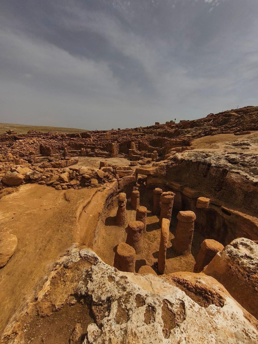
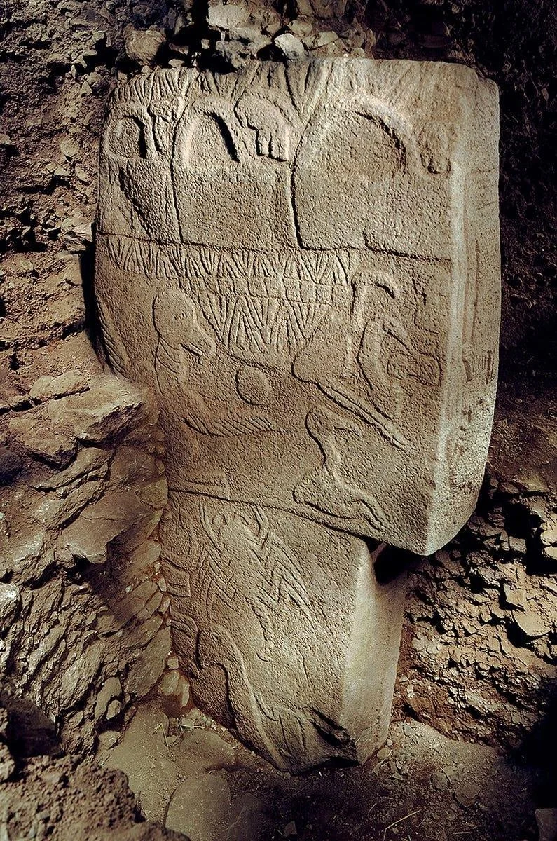
What has emerged from Karahan Tepe is a complex unlike typical early settlements. The site contains carved bedrock chambers, standing stone pillars, and sculptural elements integrated directly into the landscape. Many of the pillars resemble the distinctive T-shaped forms seen at Göbekli Tepe, some standing, others embedded in walls or emerging from the ground itself. In several areas, archaeologists have uncovered enclosures cut into the bedrock, with benches, niches, and upright stones positioned with clear spatial purpose. One of the most striking features is a carved human head rising from the stone, along with serpent-like forms and other abstract figures, suggesting symbolic or ritual significance rather than utilitarian function.
Dating places Karahan Tepe in the Pre-Pottery Neolithic period, roughly between 9000 and 8000 BCE, making it contemporaneous with or slightly later than Göbekli Tepe. This places it at a pivotal moment in human history, when societies were transitioning from mobile hunter-gatherer groups toward more settled ways of life. What makes Karahan Tepe remarkable is that its construction predates widespread agriculture, meaning the people who built it organized labor, transported stone, and created complex architecture without the social structures typically associated with later civilizations.
The identity of its builders remains unknown in the conventional sense. There is no written record, no named culture, and no direct lineage. What can be inferred is that these were highly coordinated groups with a shared symbolic framework, capable of planning and executing large-scale projects over time. The consistency in form between Karahan Tepe and nearby sites suggests communication or cultural continuity across the region. Rather than a single isolated community, the evidence points toward a network of groups operating within a shared system of ideas.
The connection between Karahan Tepe and other sites in the Taş Tepeler region is one of the most compelling aspects of current research. Multiple locations across southeastern Turkey show similar architectural elements, orientations, and construction methods. This has led to the view that these sites functioned not independently, but as part of a broader cultural or ritual landscape. Göbekli Tepe may be the most well-known, but Karahan Tepe is increasingly seen as equally important, offering different structural forms and possibly representing a different phase or function within the same system.
First recorded in 1997 by archaeologist Bahattin Çelik, Karahan Tepe remained unexcavated until the 2010s. Large-scale work began in 2019 under the Turkish Ministry of Culture’s Taş Tepeler project. Only about 5 percent of the site has been uncovered, yet finds already show remarkable artistry and organization. Excavations have revealed rock-cut chambers, freestanding enclosures with T-shaped pillars, and numerous human and animal reliefs .
The site’s best-known structure, the semi-subterranean Structure AB, features 11 T-shaped pillars arranged around a carved human head projecting from the bedrock wall and several phallus-shaped monoliths, suggesting a ritual function. Over 250 pillars have been documented across Karahan Tepe, many bearing low-relief depictions of snakes, foxes, birds, and leopards. A 2.3 m-tall limestone statue with visible ribs and a beard is among the earliest known life-size human figures. These artworks indicate complex symbolism and craft skill long before agriculture or metal tools .
Key facts
Location: Near Keçili village, Şanlıurfa Province, Turkey
Coordinates: ≈ 37.06 °N, 39.17 °E
Date: c. 9600–8000 BCE (Pre-Pottery Neolithic A/B)
Excavation begun: 1997 survey; major work since 2019 under Prof. Necmi Karul
Structures: 250 + T-shaped pillars and rock-cut shrines
UNESCO status: On Turkey’s Tentative World Heritage List
Open to the public since 2023, Karahan Tepe lies about an hour’s drive from Şanlıurfa. It is best visited in spring or autumn for mild weather. A visitor pathway and viewing platform overlook active excavations, and finds are displayed in the Şanlıurfa Archaeology Museum .