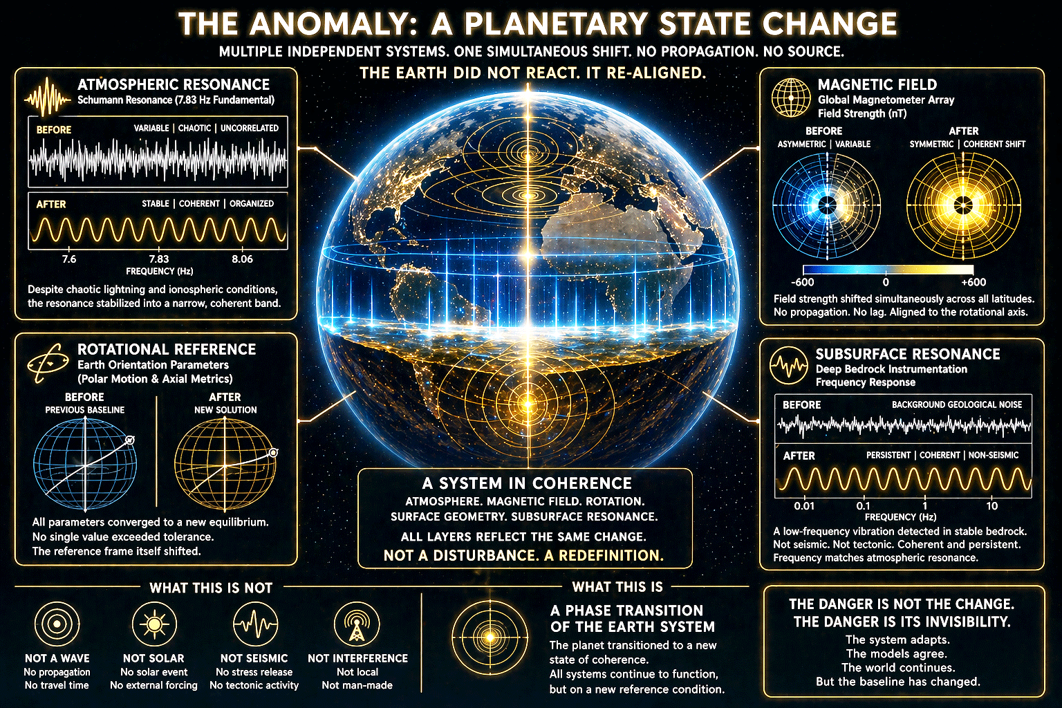
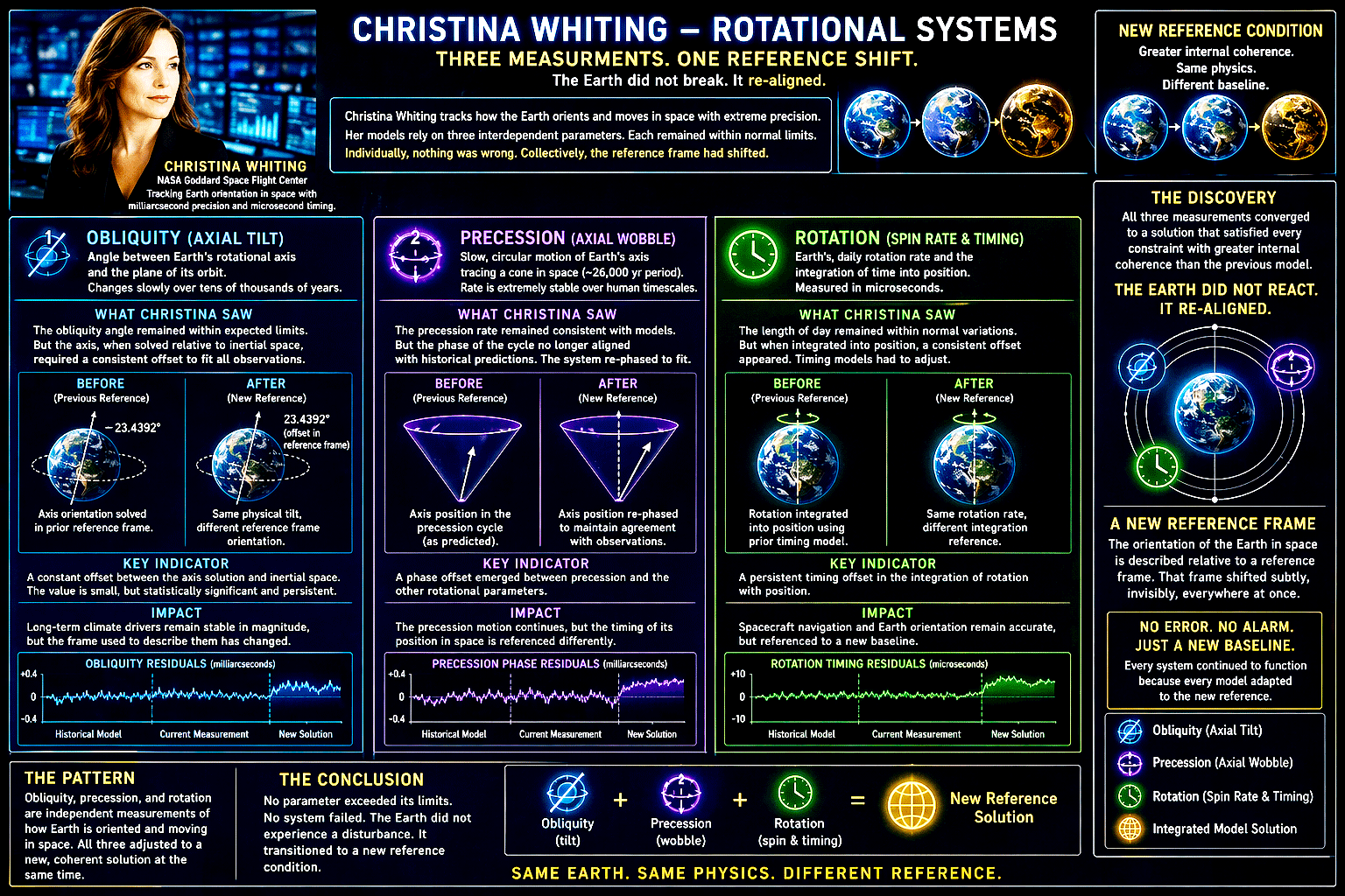
At the NASA Goddard Space Flight Center, Christina Whiting tracked how the Earth oriented itself in space, down to values that determined whether a spacecraft reached orbit or drifted into failure. Her models relied on three measurements.
Obliquity defined the tilt of the Earth’s axis, derived from satellite laser ranging and star-referenced tracking systems that fixed the planet’s orientation against distant objects.
Precession described the slow circular motion of that axis, measured through long-term VLBI radio telescope arrays that compared Earth’s rotation to quasars deep in space.
Rotation measured how fast the planet turned, tracked continuously through atomic clocks, GPS timing networks, and Earth rotation services that monitored the length of each day.
The first anomaly appeared as a spike.
Obliquity shifted by 0.002° within hours. The value dropped back toward its expected range, then stabilized 0.0003° above baseline. That residual held. Precession followed. Phase alignment shifted by 0.015°, corrected partway, then settled with a persistent offset of 0.002° relative to historical models. Rotation completed the pattern. Length of day deviated by +0.6 milliseconds, corrected partially, then held a residual offset of +0.08 milliseconds. Position solutions drifted by several centimeters and remained displaced.
Each system showed the same behavior. A spike. A partial correction. A new stable state above baseline. Across all three measurements, the pattern held.
Obliquity shifted and held.
Precession rephased and held.
Rotation adjusted and held.
Individually, each remained within operational tolerances. Together, they defined a system that had moved. Christina verified every input. Time standards, satellite ephemerides, independent sensor arrays. The data aligned across all sources. When she released the model from its prior baseline, the solution converged cleanly. The Earth’s orientation resolved with internal consistency, anchored to a slightly different reference frame. A step change.
The planet had shifted, and it remained there.
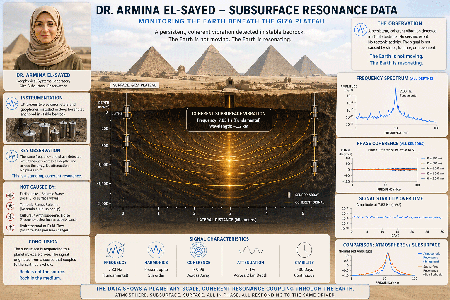
Armina El-Sayed relied on three instruments to understand what the ground was doing beneath her. Broadband seismometers measured deep, low-frequency motion in the Earth. Geophones captured higher-frequency vibration closer to the surface. Strainmeters detected physical deformation in the rock, even at microscopic levels. Under normal conditions, these signals align only when a physical process links them, such as a seismic wave moving through the ground.
What she saw did not follow that pattern. The seismometers recorded a steady, low-frequency oscillation that held a constant shape and amplitude over time. It did not rise and fall like a passing wave. The geophones began to show the same pattern. That result stood out immediately. They are tuned for different frequencies, yet the same signal appeared clearly in both systems.
The strainmeters revealed the most important detail. They recorded no deformation. The rock was not compressing, stretching, or shifting in any measurable way. That created a direct contradiction. Energy moving through rock as a wave produces strain. A lack of strain means the energy is not moving through the material in the usual way.
Armina tested how the signal behaved across distance. In a typical seismic event, sensors pick up motion at different times. The delay between them reveals how fast the wave travels and where it started. Her data showed no delay. Sensors placed hundreds of meters apart, at different depths, recorded the same oscillation at the same moment. Peaks and troughs aligned across the entire array.
She verified the timing systems against independent references. The alignment held. She then checked for signal loss. In real materials, energy weakens as it moves. Signals fade with distance. Her measurements showed no meaningful change. The amplitude remained constant from one sensor to another.
Every test pointed to the same result. The signal did not move through the ground. It existed everywhere at once within the measured area. A frequency analysis confirmed it. The oscillation resolved into a clean, repeating tone with stable harmonics. It was structured and precise.
When she compared that frequency to atmospheric data, it matched the resonance already detected above the surface. That connection carried weight. The atmosphere and the subsurface operate under different physical rules and do not naturally lock into the same pattern.
Her instruments functioned exactly as designed. They revealed that the rock was not generating the signal. It was responding to it. The ground beneath her behaved as part of a larger system, one that extended beyond the Earth itself.
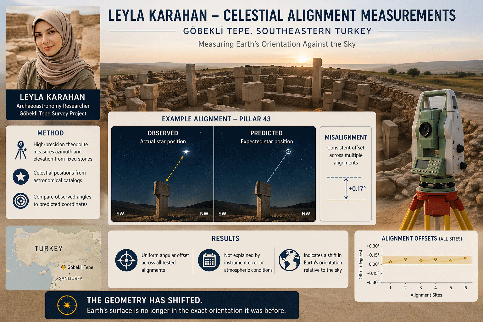
In southeastern Turkey, at Göbekli Tepe, Leyla Karahan worked from a different kind of system. She did not rely on sensors buried in rock or instruments in orbit. Her reference came from fixed stone alignments on the ground and the predictable motion of the sky above them.
The structures she studied had been measured with high precision using differential GPS and laser scanning. Their positions and orientations were known to within a few millimeters. Those values remain stable unless the ground itself shifts. Against that fixed geometry, she compared the positions of stars and the Sun, calculated from well-established astronomical models that predict where they should appear in the sky at any given time.
Her process was simple. She measured where a star or the Sun actually appeared along a known alignment, then compared that to where it was expected to be. Under normal conditions, the difference stays extremely small, often within a few arcseconds, limited by instrument precision and atmospheric conditions.
What she began to see was different. Across multiple observations, using different alignments and different celestial targets, every measurement required the same correction. The offset was small, about 2 to 3 arcminutes, or roughly 0.03 to 0.05 degrees, but it held steady. It did not change with time of day, weather conditions, or the object she measured.
That consistency mattered. Measurement error produces scatter. Atmospheric effects shift values slightly in different directions. No normal source of error produces the same offset every time. Her data formed a clean pattern instead of a spread.
Leyla checked for local causes. She recalibrated her instruments against known ground references. She reviewed horizon profiles for distortion. She applied updated atmospheric corrections using current temperature and pressure data. Each adjustment confirmed the same result. The offset remained. She then tested the astronomical models. Precession shifts star positions over long periods, but only by fractions of a degree over decades. Nutation adds small periodic variations, already accounted for in standard calculations. Neither process produces a sudden, uniform offset across all observations.
That left only one conclusion. Her measurements defined the angle between two systems: the surface of the Earth and the sky above it. Both were expected to align within known limits. A consistent deviation meant the relationship between them had changed. The structures had not moved. Survey data confirmed their positions. The celestial models remained accurate. What shifted was the orientation of the Earth itself relative to the sky.
The change was small, about 0.04 degrees, or roughly two miles over a horizon distance of three thousand miles, subtle enough to pass unnoticed in most applications. In precision alignment work, it stood out immediately. Leyla Karahan was not measuring motion through space. She was measuring how the planet was oriented within it.
Her system had no mechanism to adjust or compensate. It relied on fixed geometry and direct observation. That made the result clear. The Earth had settled into a slightly different orientation, and it remained there.
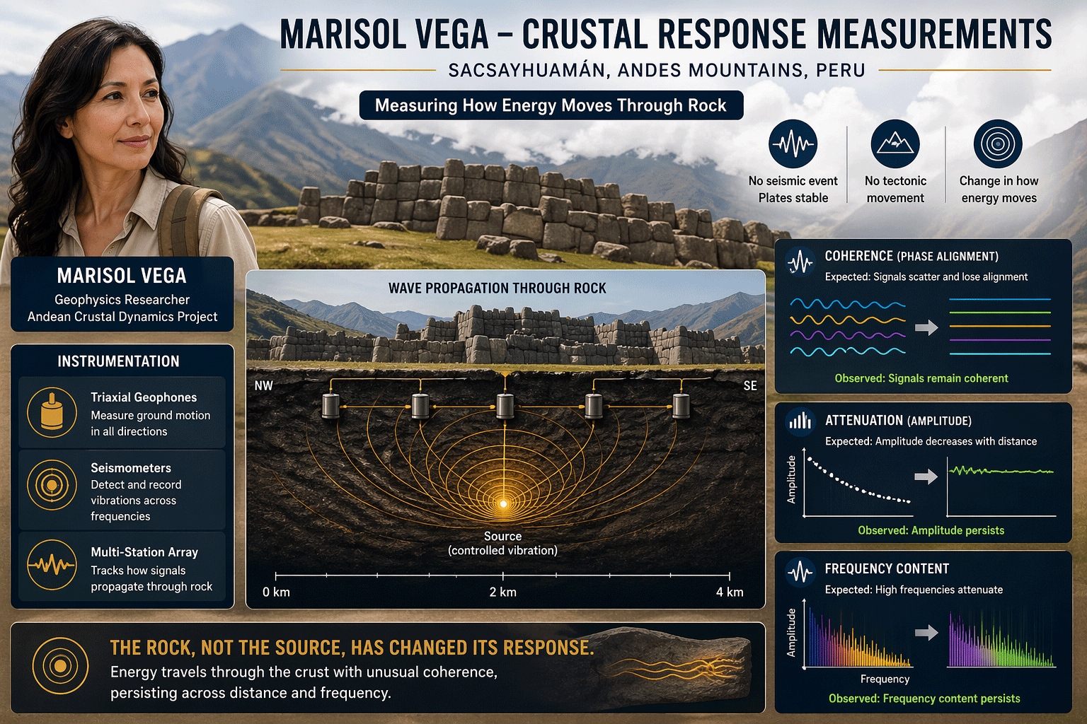
High in the Andes, near Sacsayhuamán, Marisol Vega studied how energy moved through rock. She focused on granite and diorite formations known for their complexity. Fractures, layers, and directional properties normally break up any signal that passes through them. Her instruments were designed to capture that behavior. Triaxial geophones measured vibration in three directions. Short-period seismometers tracked how signals changed over short distances. By placing them across multiple baselines, she could compare how energy arrived at different points in the rock.
Under normal conditions, the pattern is clear. Signals weaken with distance. Waveforms lose structure. Sensors record small delays between each other as energy moves through the ground. The rock itself shapes the signal.
Her data followed a different pattern. The waveform held its shape across the entire array. Sensors placed tens to hundreds of meters apart recorded nearly identical signals. Phase alignment remained consistent, with timing differences reduced to less than 0.01 seconds, well below what the geology should allow.
She tested whether frequency explained it. Lower frequencies travel farther and stay more coherent. Even then, the structure of the Andes should introduce distortion. The coherence she measured extended beyond that limit.
She then examined signal strength. In dense rock, energy fades as it travels. Amplitude drops as waves scatter and dissipate. Her measurements showed almost no loss. Across the array, amplitude remained stable, varying by less than 2 percent from one sensor to another. That result pointed to a deeper issue. The rock had not changed. Its density, structure, and composition remained the same. The way it carried energy had shifted.
Marisol moved to frequency analysis. She isolated the main signal and its harmonics. Under normal conditions, higher frequencies fade first, leaving a simpler waveform at distance. Her data showed the opposite. The full harmonic structure remained intact across all sensors. The signal stayed complex and organized.
She compared her results to known models. No seismic or human-made source produces a signal that stays coherent, maintains amplitude, and preserves structure across fractured rock without creating stress in the material. Other measurements confirmed the absence of strain. The rock was not deforming. She then aligned her data with measurements taken in the atmosphere and in deep subsurface arrays. The frequency matched exactly, centered near 7.8 Hz, with the same harmonic pattern.
That connection carried weight. The atmosphere and the crust operate under different physical conditions. A shared signal across both domains points to a common driver.
Marisol Vega reached a clear conclusion. The signal was not traveling through the rock in the usual way. The rock was responding to a condition already present within it. The medium was no longer breaking the signal apart. It was carrying it intact. The Earth had begun to handle energy differently.
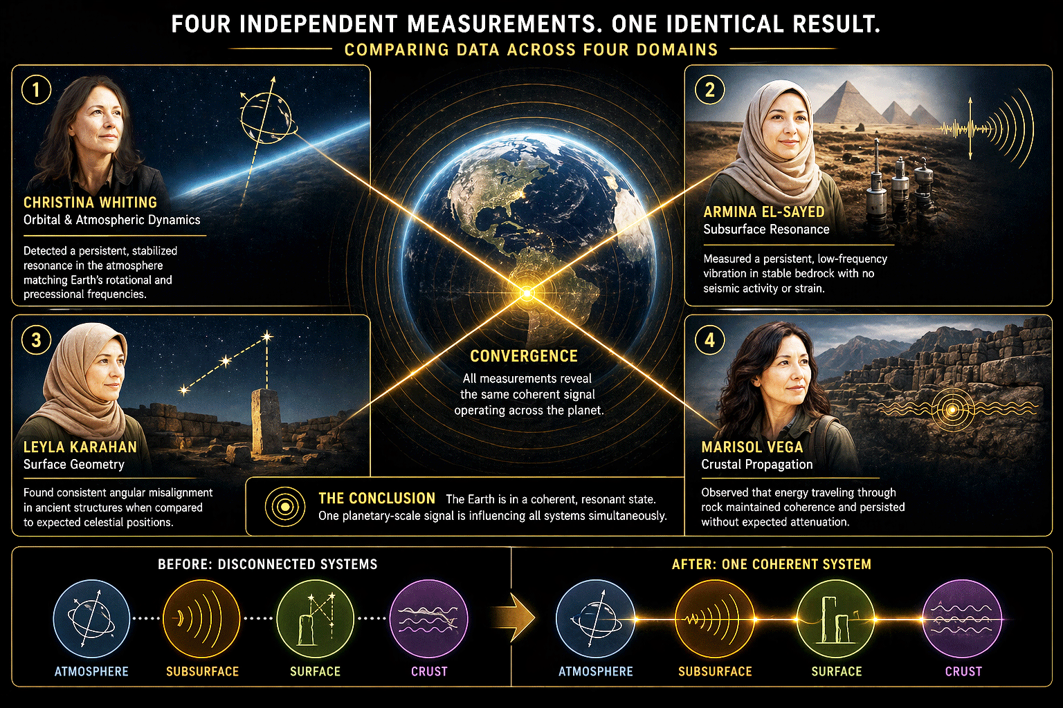
Each of these observations, taken independently, could have been questioned. Atmospheric stabilization might have been attributed to an unknown ionospheric condition. Subsurface vibration might have been dismissed as instrument sensitivity. Surface misalignment could have been interpreted as calibration drift. Changes in propagation behavior might have been attributed to local geological variation. What removed that uncertainty was the consistency across all four domains.
Christina Whiting observed a stabilized atmospheric and electromagnetic system that should have remained chaotic. Dr. Armina El-Sayed measured a coherent vibration in bedrock that should not have existed without physical displacement. Leyla Karahan identified a geometric misalignment that should have required centuries to develop. Marisol Vega recorded a change in how energy moved through the Earth without any corresponding structural change.
These are not separate anomalies. They are four expressions of the same condition. The atmosphere did not drift. The magnetic field did not propagate. The surface geometry did not gradually shift. The crust did not fracture. All four systems adjusted into a new state while preserving their internal functionality.
All of the observations point to the same fact. The Earth is changing.
Christina measured its orientation. Armina measured the response of the ground below the surface. Leyla measured the alignment between the Earth and the sky. Marisol measured how energy moved through rock. Each worked independently, using different methods in different parts of the world. They all saw the same shift.
The tilt changed slightly and held. The timing of its motion shifted and held. The length of day adjusted and held. The ground carried energy differently. The sky alignment shifted. These measurements describe a single change in the planet itself.
The pattern appearing across their work shows structure. The same frequencies appear in the air, in the ground, and in the measurements of the Earth’s position. Those domains now move together with precision. Something fundamental has shifted. The change occurred rapidly and then stabilized.
The Earth now existed in a different state.